
Table tomb about 22 metres south of Church of All Saints
Table tomb about 22 metres south of Church of All Saints, table tomb in Hollingbourne, Kent, UK
Lokalizacja: Hollingbourne
Współrzędne GPS: 51.26484,0.64065
Najnowsza aktualizacja: 23 listopada 2025 o 20:06
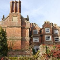
Hollingbourne Manor
234 m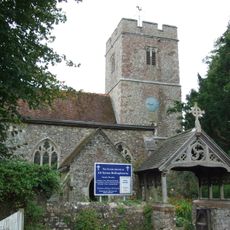
All Saints Church, Hollingbourne
33 m
Bank Cottages
382 m
Woodgate Yew Trees
364 m
The Old Forge
337 m
Wimborne House
962 m
River Farmhouse
948 m
Godfrey House
628 m
64 And 66, Eyhorne Street
951 m
The Old Vicarage
122 m
Grove House
161 m
Six Bells Cottage
88 m
Manor Farmhouse
119 m
Garden Wall About 3 Metres East Of South Wing Of Hollingbourne Manor
210 m
Malt House
313 m
The Pilgrims Rest Inn
333 m
Malt Cottage
292 m
Forge Cottages
343 m
The Old Cottage
70 m
Penn Court
245 m
Garden Wall About 3 Metre East Of Base Of North Wing Of Hollingbourne Manor
233 m
Snagbrook
458 m
Mill House
132 m
Hollingbourne War Memorial
386 m
Table tomb to Edward Charlton about 2.5 metres south of Church of All Saints
20 m
Table tomb about 2 metres north of porch of Church of All Saints
50 m
Table tomb about 2.5 metres east of vestry of Church of All Saints
26 m
Table tomb to Richard Thomas about 43 metres south of Church of All Saints
20 mRecenzje
Odwiedzili Państwo to miejsce? Kliknijcie gwiazdki, aby je ocenić i podzielić się swoimi zdjęciami lub doświadczeniem ze społecznością. Wypróbuj teraz! Możesz anulować w każdej chwili.
Odkrywaj ukryte skarby w każdej przygodzie!
Od urokliwych małych kawiarni po ukryte punkty widokowe – ucieknij od tłumów i znajdź miejsca, które naprawdę do Ciebie pasują. Nasza aplikacja ułatwia wszystko: wyszukiwanie głosowe, sprytne filtry, zoptymalizowane trasy i autentyczne wskazówki od podróżników z całego świata. Pobierz teraz i przeżyj przygodę na swoim telefonie!

Nowe podejście do odkrywania turystyki❞
— Le Figaro
Wszystkie miejsca warte odkrycia❞
— France Info
Wycieczka na miarę w zaledwie kilka kliknięć❞
— 20 Minutes