
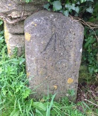
Board Of Ordnance Boundary Stone No 3 At Sx 9400 5615
Board Of Ordnance Boundary Stone No 3 At Sx 9400 5615, architectural structure in Brixham, Torbay, Devon, UK
Lokalizacja: Brixham
Współrzędne GPS: 50.39565,-3.49268
Najnowsza aktualizacja: 4 marca 2025 o 18:27
Latarnia morska Berry Head
917 m
Ash Hole Cavern
614 m
British Seaman’s Boys' Home
1.1 km
Berry Head House
593 m
Ranscombe House Hotel
1 km
Brixham War Memorial
1 km
Nos 18 And 20 Including Gate Piers On Street
1.1 km
Cod Rock
1 km
Ramparts, Counterscarp Revetment, Glacis, Musketry Wall Of Southern Fort
116 m
No 12 Including Front Area Wall And Railing
723 m
Gateway To Wolborough House
889 m
Napoleonic Fort Guardhouse, Approximately 30 Metres Inside Entrance To Northern Fort
482 m
The Old Redoubt and later Victorian Rifle Range Target, 540m south west of Berry Head Fort
153 m
Former Artillery Store Approximately 12 Metres West Of Coastguard Lookout In Northern Fort
730 m
Board Of Ordnance Boundary Stone No. 1 At Sx 9400 5595
200 m
Ruined Magazine And Blast Wall 1.8 Metres West Of Guardhouse, Southern Fort
154 m
Nos 39-49 Including Front Garden Walls And Railings
1.1 km
Sentry Box In Northern Fort, Approximately 3 Metres North Of Hm Coastguard Lookout
757 m
1, 2 And 3, Heath Road
1.1 km
Wolborough House
843 m
Hardy's Head Battery At Sx 9440 5675
522 m
Hm Coastguard Lookout In Northern Fort Including Perimeter Wall
748 m
Nos 14-32 Including Front Garden Walls And Railings
696 m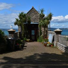
Hm Coastguard Rescue Station Including Walls, Piers, Railings At Front Approach
681 m
Slipway And Hard, Brixham Outer Harbour
1 km
Berry Head Fort and battery and Hardy's Head Battery
594 m
Ramparts, Revetments, North Battery Platform, North And South Musketry Walls Of Northern Fort
461 m
Nos 31, 33 And 35 Including Front Garden Wall
1.1 kmRecenzje
Odwiedzili Państwo to miejsce? Kliknijcie gwiazdki, aby je ocenić i podzielić się swoimi zdjęciami lub doświadczeniem ze społecznością. Wypróbuj teraz! Możesz anulować w każdej chwili.
Odkrywaj ukryte skarby w każdej przygodzie!
Od urokliwych małych kawiarni po ukryte punkty widokowe – ucieknij od tłumów i znajdź miejsca, które naprawdę do Ciebie pasują. Nasza aplikacja ułatwia wszystko: wyszukiwanie głosowe, sprytne filtry, zoptymalizowane trasy i autentyczne wskazówki od podróżników z całego świata. Pobierz teraz i przeżyj przygodę na swoim telefonie!

Nowe podejście do odkrywania turystyki❞
— Le Figaro
Wszystkie miejsca warte odkrycia❞
— France Info
Wycieczka na miarę w zaledwie kilka kliknięć❞
— 20 Minutes